Best of...

Friday, November 25, 2011

Fall in West Idaho

In the past, I’ve waxed poetically (or, at least waxed on endlessly) about the beauty of the eastern Snake River Plain. But the more metropolitan western section is also quite lovely, especially in the fall!

PB121203

The whole western Snake River Plain at a lower elevation than the eastern half (check out this map from geology.com), which creates a warmer, more temperate climate than the western portion (about ~10 degrees difference.) This makes a great environment for agriculture, and gives the eastern section the nickname “The Banana Belt.”

PB221256

The name “Boise” is a bit disputed, but the word derives from the from the French “Le Bois,” or, “the trees.” Boise is situated in a wooded river valley, while the surrounding plain is fairly sparsely vegetated with sagebrush.

PB121201

I’ve never lived in a place with so many deciduous trees – Seattle has them, but the leaves quickly become sodden with rain. It’s quite lovely to walk along the bike path and crunch the leaves.

PB121216

There’s also some scenic construction equipment. (I’m quite fond of large, colorful machinery, frankly.)

Monday, November 14, 2011

Coring Trees

P90708711_thumb2

This is not how you actually hold a corer – I was too busy posing to keep my hands in the proper position! You’re supposed to have one facing up, one facing down.

My hydrology class went out coring trees to study dendrochronology! Dendrochronology is the study of trees through time . To take a core sample, you gently screw this hollow tube into the tree, and then insert an extractor that much resembles a long-handled ice tea spoon, which grips onto the end of the core and pulls it out.

P90708551_thumb1

Much as it seems really invasive, they’ve apparently figured out a way that this doesn’t harm the tree. I like to think of it like getting an ear piercing with a hollow needle, or a biopsy.

P90808871_thumb1

Then we let the cores dry out in the lab, and our professor used a planer saw to flatten them out. Then the real work of counting and measuring rings began!

PB131226

The youngest rings are the smallest, because a tree grows from the inside-out. When the tree has grown larger, the total growth for the tree is spread out over a larger area – this results in smaller rings. In addition to marking the years on the core-holder, you also mark the core with a certain number of dots – one for a decade, two for a half-century, three for a century, etc..

PB131227

Once you get close to the tree’s center, the rings become much larger. In this picture, you can see how the rings near 1810 are curving, instead of being perpendicular to the core – this means that we missed the core. These rings aren’t very useful to measure, because it’s difficult to get a good reading on their actual width.

We correlated this data with historical precipitation data, to see how the growth reacted to precipitation. Our correlation was quite poor, since our measuring tools were fairly low-grade. (Plus, we’re newbs.) But, with the proper measuring tools, many more data points, and a lot more practice, a good correlation can be established. The relationship from this correlation can then be used as a proxy to establish possible precipitation values for the years before historical measurements exist. In addition to being a useful tool for looking at a particular region’s specific precipitation and plant growth patterns, this is one of the primary methods current climate change studies rely upon to establish past climate figures.

Friday, November 11, 2011

Jurassic Lantern

As a kid, “Jurassic Park” gave me nightmares. I would lay in bed, and think about how a Tyrannosaurus could totally hide behind my parent’s rhododendron bush. The only consolation was that my bedroom had round doorknobs - and thus was Velociraptor-proof.

PB101190

Perhaps a Parasaurolophus doesn’t have “a six-inch retractable claw, like a razor, on the middle toe. He doesn't bother to bite your jugular like a lion, oh no … he slashes at you here or here … or maybe across the belly, spilling your intestines.”

PB101178

Parasaurolophus really isn’t the scariest dinosaur around, even in lantern-form.

But when I was staring at a pumpkin, trying to think of something geological to carve for this month’s Accretionary Wedge challenge , Parasaurolophus seemed fitting:

PB101186

Especially since I spent Halloween watching Jurassic Park and enjoying some chocolate stout – the intersection of youth & slightly-less-youth.

I hope everyone had an exciting Halloween, filled with (possibly prehistoric) undead (cloned) creatures!

Sunday, September 25, 2011

Haitus

It probably went without saying, but this blog has been on a haitus for some time. (That tends to happen regularly around here.)
I would really like to share some of the exciting things that have been going on, like:
- More about the epic NASA Tweetup
- Closing the season at Craters of the Moon
- A great day agate hunting near Challis with one of my awesome coworkers
- My trip to the Sawtooth Mountains, which started with a free Symphony, and ended with a flat tire off on some BLM roads (and then a trip to the Borah Peak earthquake scarp)
- Coring trees for one of my new classes
- Visiting some awesome lava flows and ash deposits for another class
- My adorable new apartment

But, unfortunately, I've been really busy with:
- Finding and starting two (2) new jobs on campus
- Working weekends at Craters, 3.5 hours away
- Living in hostel and scuzzy motel
- Finding an apartment (and moving)
- Going to the ER
- Cancelling my last cave trip of the year
- A good friend's suicide
- and classes/field labs, of course.

Luckily, things should be easing up soon - the season is over at Craters, I'm almost done moving, and I'm shortly going to quit my soul-sucking, stressful second job.
Once I'm done dealing with the issues of the second list, I plan to write some super-awesome posts about the exciting list.
But, in the meantime, I'm just going to try to keep my head above water and not flunk out of school.

You know, priorities and adult choices, etc.

UPDATE: The next few weeks consisted of:
- Flying home for the funeral
- Maternal visit
- Getting really sick...
- ...during midterms
- Car failure
- Bike theft

But my classes are awesome, my job is fun, and my house is lovely!

Monday, August 1, 2011

NASA Tweetup Pt. 2: Astronauts & Astronuts

Flying in over the Gulf of Mexico on July 6th, reality hadn't really set in. I tried to convince myself that I was, in fact, going to Florida, to see a space shuttle launch. Despite my best efforts, thoughts of the events to come couldn't quite force out the thoughts of our imminent water landing and demise.
Gulf of Mexico, via airplane
The Gulf of Mexico, from the airplane 
After touching (safely) down in Tampa, I met up with a couple of my housemates – @Thatgirlallie and @whoisgregg – who were driving in from Tampa. We talked about how we came to the tweetup, went through the slowest drive-through imaginable, and ended up picking up another one of our housemates who was stranded at the Orlando airport @j4cob). We dropped our stuff off at #DiscoveryHouse, met a few more of our housemates – @MeganPrelinger, @CaliforniaKara, and @LisaAMcGill – and went off to listen to a band at an Irish pub.

Now, I also didn’t understand why we were going to an Irish pub while in Florida, but it turned out that the band has several members who are – I kid you not – astronauts.

That’s when reality started to sink in.

Cady Coleman (@Astro_Cady : STS-73, STS-93) on the flute,
and Chris Hadfield (@Cmdr_Hadfield : STS-74, STS-100) on guitar (left).
 Photo graciously from @AdamZ .
We met up with the other houses in the area – #OmegaHouse and #HC39A – as well as our last housemate, @SWGlassPit, and began getting to know each other. It was much akin to meeting any group of people – where are you from, what do you do, what brought you here – except the answers ranged from “I’m just an administrative assistant” to “I’m an engineer for NASA.” There were lifelong space geeks fulfilling childhood dreams, and space enthusiasts there for the conversion - I mean, experience. The diversity of the those attending was impressive, and made for a well-rounded and inclusive community.

One of the most impressive things about this community is its eagerness to teach others and share information, without being condescending or pretentious. (In this manner, I found SpaceTweeps much akin to GeoTweeps.) But what impressed me the most was that, despite wildly disparate backgrounds and knowledge levels, everyone met each other on a (mostly) level playing field: having this incredible opportunity to get excited over the space program, meet incredible people, and watch the historic final launch of the space shuttle.

Much as we had a lot to talk about that night, we ended the evening fairly early: it was time to rest up for the eventful days ahead.

Wednesday, July 6, 2011

NASA Tweetup Pt 1: Heading Out

Things have been really busy recently, and I haven’t had a chance to write a post about an important recent development: I got into the NASA Tweetup for the final space shuttle launch!!!!

Over the next three days, I’m going to be meeting all sorts space nerds, scientists, astronauts, and the administrators who make the launches happen. We’re going to take behind-the-scenes tours of Kennedy Space Center, and watch the shuttle launch from 3 miles away (in the press area.) Only 150 of NASA’s Twitter followers were selected to attend this event, so it’s quite a privilege and honor to be able to go.

A little bit of background: the last shuttle launch is scheduled to take place at 11:26am, Eastern Time. The Atlantis (named not after the mythical city, but rather after a research vessel from Woods Hole Oceanographic Institute between 1930 and 1966) will be making a 12 day mission to deliver cargo to the Space Station: mainly,  the Multi-purpose Logistics Module called Raffaello. This is a pressurized container filled with stuff; in this case, equipment and supplies to provision the Space Station after the Shuttle Program ends. It’s also going to carry up an experimental gadget designed to robotically refuel satellites while in orbit, an autonomous docking gadget, and carry some broken pieces of the Space Station back down to Earth.

Until a week ago, I was uncertain how to make it all work out. Switching shifts when working in a customer service position can be really tough: no one wants to be that jerk who left the visitor center short-staffed, annoying coworkers and bosses alike. My car had a minor breakdown, but for a spell I couldn’t figure out how I’d get to Boise. Both payday and the Flight Readiness Review (one of the final checks before officially setting the launch date) were on the 28th, so I was biting my nails that day. For various reasons, my ticket got booked for the wrong return date – another problem to deal with.

(Note: buying a plane ticket a week in advance prompts the airline to have the stewardesses come check you out personally. Their fears of rampant delinquency were quickly allayed when they realized that the seats surrounding me were filled with National Guardsmen. Who could make any sort of trouble when surrounded by soldiers with guns?)

Because of all the shift-switching, I worked eight 9-hour days in a row, and finally got into Boise last night at 2:30am, where I managed to catch a couple hours sleep in the parking lot of the local Wallmart, before waking up at 4:30a to get to the airport.

Right now, I’m delayed in the Phoenix airport, but hopefully soon I’ll trade this lovely scene:

P6221216

for this one:

atlantisNASA

Is all this trouble (and money) worth the possibility of seeing a space shuttle launch? Totally. I’m so excited I could spit, and the reality hasn’t even really sunk in yet. I’m probably going to cry.

Even if it doesn’t launch, I’m sure I’ll still have a great time geeking out about space, shuttles, and NASA with other like-minded people. I’m staying in one of the group houses, right near the Atlantic ocean (!!) and going to the Everglades post-launch, so it should be a really great experience no matter what.

But I really hope the Shuttle launches as planned!

Monday, June 27, 2011

Cinder Cone Hike

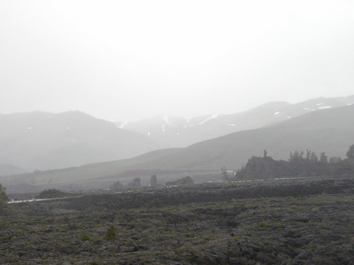
The hazard of living in new places is that, as soon as you step out your door, you see something fascinating. Here, I live atop a volcano that last erupted about 2,000 years ago, so all manner of exciting lava features are present. We have lots of time to explore the lava: we live 18 miles from the nearest civilization, and have no cell service or wifi, so our spare time consists mainly of reading, watching movies, and hiking. (Rough life, eh?)
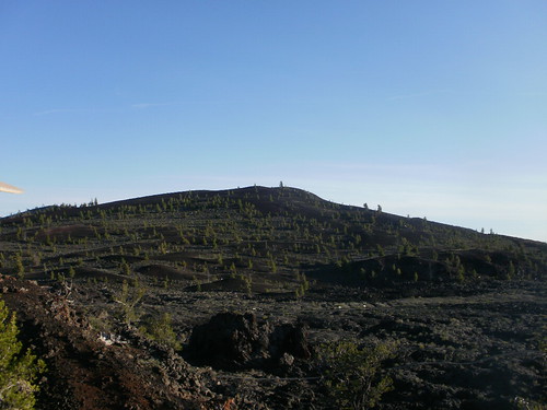
A couple weeks ago, some of the rangers and I decided to go for a short hike up one of the cinder cones. While we were only out for a couple hours, we saw a huge variety of interesting things.
P6050781
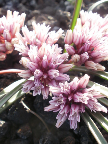
Wild alium (or onion) grows frequently on the sides of the cinder cones, and was just beginning to bloom. Native Americans used to use the bulbs in soup.
P6050820
Many of the cinders here exhibit an iridescent, glassy sheen oddly reminiscent of an oil slick. (This iridescence shows up quite poorly in photographs, but is gorgeous in person.) I haven’t yet heard a satisfying explanation of how this happens, but I’m exploring it.
P6050601
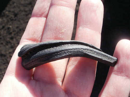
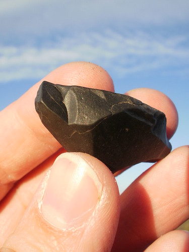
This is a ribbon bomb – the result of a small piece of lava stretching out and cooling as it flew through the air. This one seems to have twisted a little as it flew, resulting in this curled shape. This was the first time I’ve found bombs in the wild, so I stopped to examine every single one.
P6050830
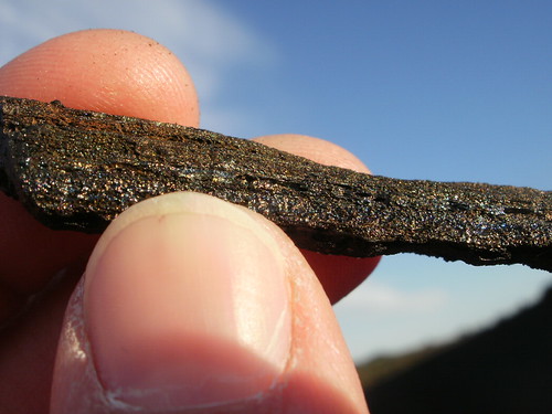
This is an iridescent ribbon bomb, which was quite exciting to find. Best of both worlds!
P6050804
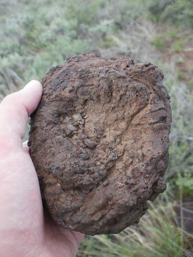
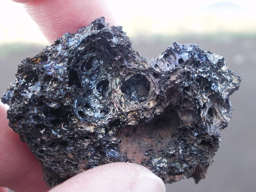
This is a type of volcanic bomb called a cow-pie bomb. They’re the result of a glob of erupted lava that began cooling, but was still partially liquid when it hit the ground, resulting in a squished appearance that exactly mimics that of a cow-pie.
P6050811
When I first saw these cow-pie bombs, I thought “Oh, best not put my foot in that,” and advised my companions of the hazard.
Whereupon, one of the more experienced rangers reminded me that there are no cows in the National Monument.
We’re not in rangeland anymore, Toto.
P6050612
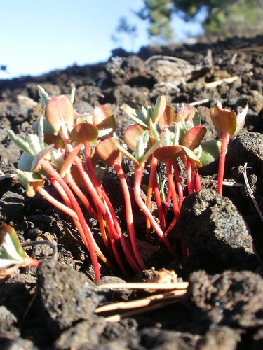
This is some bitterroot just beginning to grow. Bitterroot has gorgeous white or pink flowers, which are usually between 1 and 2.5 inches across – a little larger than the plant is tall. The roots were used as a food by the Native Americans: the bitter taste disappears when boiled. These are some of my favorite flowers, so I’m quite looking forward to when they bloom.
P6050833
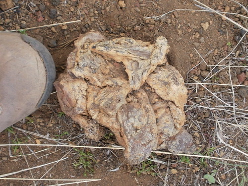
We found a few chunks of tachylite, a type of volcanic glass that forms when lava cools very quickly, without having time to crystalize at all. This is like obsidian, but basaltic instead of rhyolitic. They’ve found a couple arrowheads made of tachylite here, but most of the arrowheads found here are obsidian from nearby Big Southern Butte, or from an obsidian bed in Utah.
P6050771
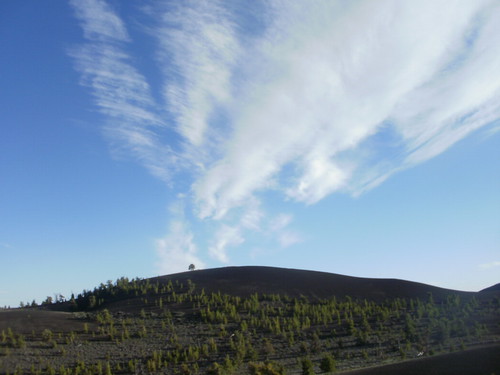
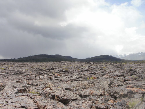
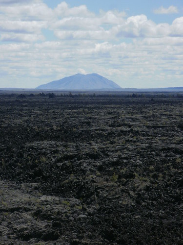
One of the best parts of climbing up the cinder cones is the great view that one gets of the other nearby cones. This one is Inferno Cone, which actually has a short, steep trail up one side for visitors to climb up. Learning the names to so many cinder cones was a little tough at first, but this one is really easy to recognize this one because it’s entirely black, with a lone tree on top.
P6050641
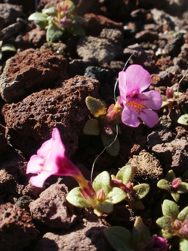
This is a dwarf monkeyflower, and it’s the another pink flower that favors cinders. These flowers are quite small – between a half inch to an inch. These flowers are growing mainly on the loess that has settled down amidst the cinders, rather than any homegrown soil – not enough time has passed for much of this lava to break down into soil.
P6050699
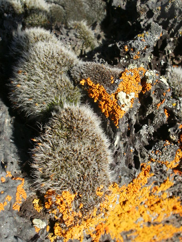
Any home-grown soil that is found here owes much of its existence to lichen. We found many delightful varieties of lichen on this hike, in just about every color, including this fuzzy gray one. This lichen actually turns green if you pour water on it – definitely a fun trick. Lichens are a symbiotic relationship between a fungi and a lichen, and they are some of the first organisms to live in lava fields, breaking down the rock and forming soil for first mosses, then plants and animals, to live in.
P6050870
(I also discovered my camera’s filters that day.)
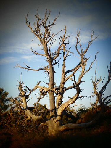
This is a dead Limber Pine tree. These trees are very bendy, in order to cope with the wind, and frequently only have branches on one side. This one may have been killed by Dwarf Mistletoe, a native parasite that attacks the limber pine.
Living where you work can be kind of strange and stressful, but the location entirely makes up for it. When I have time, I really relish getting out of the house, off the beaten path, and into the sunshine – especially since the rocks and plants are fantastic.

Tuesday, June 14, 2011

Washington to Idaho Road Trip, Featuring Basalt

About two weeks ago, in May, my mother and I set off from her house in Seattle to travel to Idaho. I live (and now work!) in Idaho, but was back home to visit my brother and sister-in-law, who were in town for a spell (and newly expecting a baby!) This trip was held together tenuously from the beginning, and quickly began to disintegrate along the way. Luckily, we got to see some awesome stuff along the way.

MSH2Our first stop was Mt. St. Helens, always a favorite stop. I’ve never been here so early in the season, so I’ve never seen it so snowy! This iconic view from the Johnston Ridge Observatory really lets you look into the crater and see the lava domes (here, due to the snow, they look like a vague bump towards the back of the crater.) This spot also gives you a good look at the Pumice Plain, (the low area in the foreground) that consists of debris avalanche hummocks mostly covered in pyroclastic flows and ash fall deposits.

P5240338

This is a nice outcrop near the Johnston Ridge Observatory, that really clearly demonstrates the layered nature of stratovolcanoes. You can see different lava flows (andesitic and basaltic) alternating with layers of ash and possibly pyroclastic flows (in this instance, I’m not sure which it is, or whether it is a combination of both.) All the different colors are a result of hydrothermal alteration on groundwater that seeps into the deposits, is heated by the still warm deposits, and encounters pockets of gas.

Once we left Portland, the cold my mother had been fighting off finally caught up to her. We stopped in a town called Cascade Locks for the night, slept in late the next morning, and then got some restorative chowder before heading out.

ColumbiaRiverRowenaBendsWe took a short side trip off I-84 on an Oregon 30 between Mosier, OR and The Dalles, OR. When I was first moving to Idaho, we discovered this scenic jaunt, and it was great to see it again. Partway through, there’s an overlook of the Columbia River and the Columbia River Flood Basalts at a place called Rowena Crest.P5250378

The road down from the overlook is this delightful road called the Rowena Loops. It’s quite exciting (especially for one’s passengers!)

P5260389

Somewhere along the highway near Pendleton, we pulled off the highway to look at this cool cement plant. After this, though, we encountered some pretty intense rain, and ended up staying in La Grande for a night.

P5260396

Once we got to Boise and picked up my car, we joyfully discovered that it had some sort of gas leak. (This heap – I mean, jeep is beginning to get on my nerves.) We dropped it off at the shop, and drove into the foothills above Boise to camp. Along the way, we stopped at Diversion Dam. It was built in 1909 to supply water to another, older system of canals, to irrigate nearby farmland.

P5260414

One of the cooler things about it was the logway – a special portion of the dam constructed to allow logs from logging upstream to pass through the dam. (The area upstream is the Boise National Forest)

P5260421

It was interesting to see how the water from the less constricted logway (on the left) interacted with the water that was forced through the dam. Despite having an initially smaller outlet, the greater force enabled it to travel farther & spread out more before the turbulence achieved equilibrium. (I’m sure there’s a better way to phrase that, but my engineering-oriented physics class didn’t cover fluid dynamics… which is what I personally wanted to study! Someday maybe I’ll get to.)

P5260441

We passed by several reservoirs, including this one. The differential erosion happening in the basalt here was really fascinating – the lower flow must be much harder, to have resisted so much more than the upper flow.

P5260451

The road passed through areas of this potassium feldspar rich granite. The best exposures were alongside one of the dams, where the road was quite literally one lane carved into the cliffside, frequented by large trucks hauling boats. Needless to say, we didn’t really stop for picture taking.

P5270460

When we finally began pitching our tent, we realized that the rainfly was still in Washington – and rain was predicted. My mum had this great idea to make one out of free garbage sacks and little bits of tape – which luckily worked pretty well, though it didn’t rain.

After that, we picked up my car (which luckily only had a leak in the fuel lines!) and checked the weather forecast. Since it was predicted to rain more and my mum was still under the weather, we decided to part company that day, instead of camping through the weekend. She headed west to Washington, and I headed east to my summer job. Much as a few days of mother-daughter camping would have been fun, it was nice to just call it quits and end the stress.

Sunday, June 5, 2011

Weird AND Scenic: Accretionary Wedge #34

“… a weird and scenic landscape peculiar to itself” was how President Calvin Coolidge described Craters of the Moon when he proclaimed it a National Monument in May of 1924. For my entry in the Accretionary Wedge #34, hosted by the lovely Dana Hunter over at En Tequila Es Verdad, I'd like to talk a little bit about some of the weird things we have here!

In 2000, the original boundaries of the Monument were expanded to overlap with an area of BLM land, and the area is now managed cooperatively by the NPS and the BLM, and is now a National Monument and Preserve instead. I’m working this summer for the BLM, but am stationed at the NPS Monument, to increase knowledge of this cooperative management. *

The name and managing organization may have changed, but the landscape remains, well, weird. And scenic.

Blue Dragon Flow

Craters of the Moon is comprised of about 60 lava flows covering 54,000 acres, and spanning 13,000 year of time. This is the most recent area of volcanism on the Eastern Snake River Plain; altogether, the sheer mass of lava erupted throughout the ESRP has depressed the crust, resulting in a (mostly) flat valley 100 km wide. The eruptions at Craters of the Moon are the result of a 52 mile long tear where two plates of the Earth’s crust pulled away from each other, much like in Iceland or sub-Saharan Africa. The volcanoes in this picture are cinder cones that formed alongside the Great Rift.

Blue Dragon Flow

This picture shows a close-up of the same lava pictured above. This is the Blue Dragon flow, named because it’s spiny texture and blue glass coating reminded early explorers of the skin of a blue dragon. The spiny texture is the result of bubbles in the lava being stretched and popped as the flow moved; the origin of the blue glass is still unknown, although it is suspected to either be the result of higher than normal titanium concentrations or a process similar to “glazing” a pot.

Big Southern Butte

This picture illustrates another reason why Craters of the Moon is weird: bimodal volcanism. In the foreground, we have the fluid basaltic lava flows of Craters of the Moon, and, in the background, the 800 meter tall rhyolitic dome of Big Southern Butte (which lies outside the monument.) This butte was formed when very viscous lava flows piled upon one another. (It is also thought to extend about 1000 meters below the surface of the earth, but has isostatically sunk due to it’s weight.)

The compositions of these two lava types are about as disparate as lava types can get: basalt has low concentrations of silica, and rhyolite has high concentrations of silica. It is suspected that, in this location, the two lavas come from roughly the same origin, but proceeded through different paths through the Earth, which resulted in differing compositions. They both are a result of the Yellowstone Hot Spot heating the asthenosphere as the North American plate passed above it. The rhyolitic lava travelled up through the continental crust above, melting it and absorbing the silica. Later, when crustal extension of the basin and range province stretched the area out, the silica-poor crust melted (mainly by decompression), and cracked open, creating the rift zone at Craters of the Moon. Gravity readings under Craters of the Moon suggest that there may be a thick sill of gabbro, that was once part of a reservoir for feeding the basalt flows above the surface.
Rafted Crater Wall Blocks

Another really weird part of Craters of the Moon are the blocks of lava shown in the center of this picture. One of the more recent flows of the North Crater broke apart the crater wall, and rafted chunks of the wall along the top of the flow. These crater wall pieces dot the landscape in an eerie monolithic fashion, like something out of 2001: A Space Odyssey.
North Crater

And here’s the North Crater itself, with one of the rafted blocks in the foreground. The area where the flow broke out is on the back and right side of the cone seen here. The asymmetrical shape of this cone is due to the cinders accumulating on the downwind side of the vent.

Early emigrants passing through this area by wagon train described this area as “black vomit.” These early emigrants, after travelling across a harsh and demanding area, almost entirely void of water or shelter, were too weary to contemplate appreciate the landscape. Those of us privileged enough to visit in this modern day find it easier to look past the difficult environment to the gorgeous volcanic scenery and awesomely weird geology.

* Normally, I wouldn't say who I work for, however my lawyer-mother recommended I do. Plus, it's pretty stinking obvious. Please don't think anything I say is the official opinion of the BLM or the NPS, and remember that I'm still learning about this area and geology generally. Also, please don't stalk me. If you're in the area, however, please feel free to say hi!

Wednesday, May 25, 2011

Airplane scenery, Boise–Seattle

After finals, I decided to visit some family and friends in Seattle for a few days, before travelling out to my summer job. There was much hurried packing and rushing and I barely made it to the airport with an hour to spare.

Which was fine, since my plane was grounded for four hours due to mechanical difficulties.

Once we finally made it into the air, we saw some great airplane scenery.

P5160098Sad plane.

P5160105
Looking at the Snake River Plain from a (snakeless) plane. (The Western Snake River Plain is a large graben.)

P5160124
Mt. Adams, seen from a distance.

P5160130

Admiring Mt. Rainier while sipping some (free!) white wine made for the perfect flight.

P5160155

Then we descended into the clouds, which oddly reminded me of the Titanic sinking…

P5160162

… and arrived atop Seattle! This is I-90 floating bridge that crosses Lake Washington, with some nice drumlin hills in the background. (Lake Washington is a ribbon lake that formed when the Cordilleran ice sheet was sculpting the region, and acted as a drainage point for the ice sheet as it melted.)

airplane

We also got a nice view of Boeing field, a small regional airport used primarily for small airlines, private planes, cargo flights, and military landings. (It was originally used as a place for the Boeing Company to move their planes about, and is still used for tests to this day.)

P5160182

Then we got a nice view of downtown Seattle and the Puget Sound.

P5160180

And, last but not least, the Space Needle.