Best of...

Showing posts with label disaster. Show all posts

Sunday, January 22, 2012

It's a Branch, It's a Pothole - no, it's an Earthquake!

For December’s Accretionary Wedge, (#41!) Ron Schott has asked us to describe the most significant or memorable geologic event we have personally experienced. The first thing that sprang to my mind was the 2001 Nisqually Earthquake.
WUAZ
This is the seismograph from Wupatki, Arizona. There weren't many closer, and I quite liked how clearly the P-wave and S-wave showed up in this one.
In February of 2001, I was 13 years old. At that time, I was half-homeschooled – I took a couple classes at the junior high in the morning, and then my mum picked me up for some homeschooling. (Reality: I’d wait until she left on some lawyer-ly errand, and then make grilled cheese and watch Wheel of Fortune. What a rebel.)
On February 28, at 10:54 am, I had just been picked up from school, and we were driving in my mother’s 1870s powder-blue Camaro towards The Big Swoopy Hill. All of a sudden, the car swayed back and forth, the dashboard tilting up and down. It looked like that One Time My Dad Took the Car on the Potholed Forest Service Road Where People Go Mudding.

“Mum, do we have a flat?” I asked.
“No, I don’t think so. We might have run over a downed branch.” My mum looked in the rearview mirror. “Although I don’t see anything behind us…”
“Mum, look at the lady parked on the side of the road!”
“She’s getting back in her car, she’s ok.”

After we got back home, my mother worked on some legal briefs, and I worked on my report on deciduous trees. After an hour or so, the phone rang.
My mum picked it up. “Hello?”
“Are you ok? Is the house ok?” my dad asked, frantically.
“We’re fine… Are you?”
“There was an earthquake!”

We walked around the house, and, sure enough, some of the vases on top of the piano had shifted a little. The dishes had moved.

The next day at school, my classmates regaled me with tales of crawling under their plastic-topped desks, all the while imagining the back half of the portable buildings sinking into the ground. One girl even declared that she’d thought it was the Rapture.
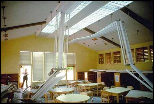
fig31
This is from a school near Nisqually. Our school only had a couple lights fall down, and was otherwise fine.
I tried to explain our harrowing tale to them, but even my best retelling didn’t convince them it was cooler than the Rapture.
vroomvroom
Well, I tried.
The 2001 Nisqually earthquake only rated a 6.8, with a depth of about 52km, and is an example of normal faulting in a subduction zone – the Juan de Fuca plate was bending (and stretching) as it was forced under the North American plate. This is possibly due to increased warmth near the mantle heating up the subducting plate, dehydrating it and making it more brittle - kind of like baked potato chips.
foc
A fault plane solution for the Nisqually earthquake. The little circles are dilatations, and the little stars are compression - so you can see how part of the plate extended, compressing the material to either side.
cap-lake-lspd7
A path near the State Capitol. One fellow looks depressed at the thought of all the work he's going to have to do. The other fellow looks like this is the coolest thing to ever happen - definitely a geologist.
Luckily, only one person died (as the result of a heart-attack) and 407 people were injured. It did cause significant damage to roadways near the epicenter (in the Olympia and Nisqually area.)
img026
Highway 101 - nobody really uses the right lane, do they?
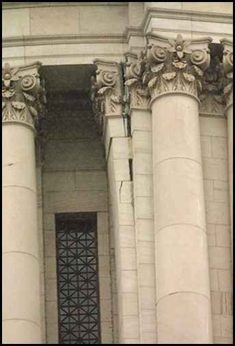
Additionally, it caused significant damage to buildings both in Olympia and Seattle – including causing a large crack in the dome of the Washington State Capitol in Olympia.
2014342999
The exterior of the State Capitol. You can see that some of the bricks are separating from the facade. The building was shut down for quite some time as it was examined for structural stability.
photo01
Looters run rampant in downtown Seattle.
These fellows actually just found a co-worker's purse amidst the wreckage of their van.

2014343028
 "Pssh, I've got nine lives, I ain't scared."
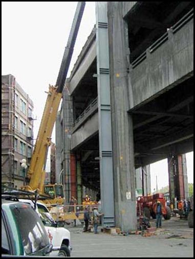
It also damaged the Alaska Way Viaduct in Seattle, which led to a decade of plans, negotiations, and general strum und drang about replacing it, as well as this terrifying simulation. Apparently, they’ve now begun construction on a replacement. The earthquake resulted in $3.5 million in repairs to the viaduct, and construction of a replacement/refurbishment/tunnel/etc. is projected to cost $3.1 billion. It’s money well spent, I think, because that sucker looks like a car-sandwich just waiting to happen.
DAMAGE_Repair4
Some fellows braving aftershocks to repair the Viaduct so people can tempt fate.
There were also spots of liquefaction and sand boils in both Olympia and Seattle. Liquefaction is pretty nifty, and luckily didn’t cause much damage in this earthquake. (Many portions of Seattle’s waterfront are built on fill – liquefaction could be a huge problem for those areas.)
nisq-delta-6
A sand boil in Olympia.
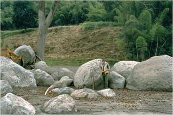
While much of the liquefaction seems to have been little sand boils, it also invaded basements. Additionally, there was a large mudslide in the Renton area, which also did significant property damage.
dsc00303
Worst sweeping job ever.
I’m really glad that I was able to experience a medium-sized earthquake, without my family suffering any damages, and without the region suffering many deaths. I do still kind of wish we had realized it was an earthquake when it was occurring – that would have been so much more terrifying and exciting! But it was still a very memorable experience.


In addition to the websites linked through the above photos, here are some websites with information on the Nisqually earthquake:
Some Observations of Geotechnical Aspects of the February 28, 2001, Nisqually Earthquake in Olympia, South Seattle, and Tacoma, Washington
Geodetic Information from Central Washington University
The Nisqually Earthquake Information Clearinghouse, housed by the University of Washington
GPS Analysis of Olympia Quake from Rensselaer Polytechnic Institute
The Pacific Seismic Network's Nisqually Earthquake Page
USGS's Preliminary Earthquake Report
Washington State Department of Natural Resource's Nisqually Earthquake Page
Identifying the Rupture Plane of the 2001 Nisqually, Washington, Earthquake
A Video Taken Inside Microsoft During the Earthquake
KOMO News Broadcast from February 28, 2001
Car image: http://bit.ly/x4x9RL

This video made me laugh so hard I cried. It's ridiculous!


Wednesday, March 23, 2011

Yellowstone Pictures, Pt. II

I’m over on the east coast, doing some family visits, and thought I’d use the occasion to post some photos from this past summer/fall, that have heretofore been unpublished. This first set is from a trip to Yellowstone – there are a few more pictures here.P1240403

The entrance sign near West Yellowstone, WY. (Which has an incredible 4th of July fireworks show!)

DSCF5084

Mud pots! (I bet that’d make a great face mask… not that I advise trying!)

DSCF5101

The view overlooking one of the geyser boardwalks. It was really comforting to think about so many people enjoying and learning about geology!

DSCF5113

Spasm Geyser.

DSCF5178

Near Prismatic Spring. (I overheard a private tour guide saying that the best viewpoint for Prismatic Spring was actually the parking lot for Fairy Falls, but we didn’t get a chance to check out that tip.)

DSCF5204

Sunset Lake.

P1240418

The Old Faithful Inn’s interior is spectacular! (And the ice-cream is very good also.)

P1240427

Old Faithful Geyser.

P1240450

Avoca Spring, possibly.

P1240474

Hint: Madison campground has no showers - which means that you can frequently get a site without a reservation!

Another hint: Getting a back-country hiking/camping permit is pretty easy, but watching the Bear Country Camping video does take some time. As does buying the required bear spray and ropes for hanging food. Oh, and they like it if you research trails in advance, instead of showing up the day of and asking for whatever slots are open. We got a permit, but by the time we got to the trailhead, realized we couldn’t get to camp before sunset, when the bears come out to rummage through your groceries, and the rangers require you to be off the trails.

Another hint: advance planning is probably a good idea when visiting a major tourist attraction! We had a good time, but that would have made it a great time.

P1240451

(Another note for unprepared/impromptu travellers: if want to hike the Grand Canyon, but lack the permit/reservations, you can sometimes get cancellations the morning of! My family’s actually had that work out twice. You definitely want to be in sufficient physical condition, however!)

Sunday, November 14, 2010

The People of Armero, 25 Years Later

It’s been 25 years since Nevado del Ruiz erupted on November 13, 1985. Despite being a relatively small eruption (VEI 3), this phreatic (magma + water) created a massive lahar (mudslide) and managed to wipe out an entire town, killing 23,000 people in the process. Good descriptions of the eruption can be found on History of Geology and Eruptions, so I’m not going to reinvent that wheel.
image
From the USGS
Last spring, I researched Armero in the present day for a cultural project in Spanish class. The assignment was to communicate with a native Spanish speaker in Spanish, so I sent a (painstakingly composed) email to  Observatorio Vulcanológico y Sismológico de Manizales, one of the volcano observatories set up after the 1985 tragedy.
Now, it has been 25 years since Nevado del Ruiz erupted, and, in the aftermath of eruptions, frequently people return to the destroyed area. There could be a variety of reasons for this – they don’t think it’s likely to erupt again, they have nowhere else to go, for religious reasons, or they simply want to be “home.” A great example of this is Merapi, in Indonesia, which seems to erupt roughly every ten years, and its lahar deposits re-liquify into new lahars every monsoon season. That people still live nearby to be affected by the current eruption is a horrific testament to misplaced perseverance, determination, and religious conviction. After the 2002 eruption of Mt. Nyiragongo, in Congo, people moved back to the destroyed town of Goma before the lava had even finished cooling. However, habitation in an area previously destroyed by recorded natural disasters isn’t relegated to what we would consider “third-world” countries: people still live in New Orleans and near Mt. St. Helens, astonishingly enough. As time passes after an eruption, people are increasingly more willing to return to these areas – the valleys surrounding Mt. Rainier are filled chock-a-block with farms, industrial complexes, and towns.
image
From here
In light of that, my curiosity about Armero was regarding where in that process the government and people were – had they begun to forget, or did the scale of the tragedy make it more difficult to ignore the hazard? Had I known more vocabulary, I might have asked more specific questions, but the ones I managed to include were thus: what is the town of Armero like today? How many people have returned to live there, and how do they perceive Nevado del Ruiz?
I got a fantastic response back from the volcano observatory, which, after some I looked up several words, answered most of my questions. The representative explained how the old site of Armero had been declared a National Cemetery, and habitation was no longer permitted there. Now, the survivors and municipal administrators had moved to the town of Guayabal, now called Guayabal-Armero. Apparently the area has become a destination for over 35,000 tourists a year, and there are volunteers available to provide tourist guidance.
image
From the USGS
That led to some more focused googling, with the result that I found out about the Fundacion Armando Armero, an organization devoted to preserving the cultural heritage of Armero. They’ve set up an interpretive site in the old town, focusing on people and places found in Armero before the eruption. In addition, they are working on building a cultural-tourism route through Guayabal-Armero and Armero. One of their other projects includes collecting photos and stories of old life in Armero, some of which are available on their website.
From Wikipedia
It was interesting to learn a little more about how this area is recovering from such a devastating incident. It sounds like the government has more respect for volcanoes, that the people are coping, and the efforts of the Fundacion Armando Armero are laudable. Still, I wonder whether the cooperation of the people will last, or whether they will someday decide to reclaim their town.

Other Resources:
Observatorio Vulcanológico y Sismológico de Manizales
 USGS: Nevado del Ruiz
Global Volcanism Program: Nevado del Ruiz
No Apparent Danger, Victoria Bruce, HarperCollins Publishers, 1st Ed., 2001